The Waikato River Trails is a 103-kilometer network of cycling and walking paths following New Zealand’s longest river. Stretching from Atiamuri to Pokuru, the trails are divided into five distinct sections featuring suspension bridges, native forests, and hydro dams. This trail system offers a diverse eco-tourism experience suitable for intermediate to advanced riders and hikers.
Understanding the Waikato River Trails Map
For eco-tourists and outdoor enthusiasts visiting the North Island of New Zealand, the Waikato River Trails represent one of the premier “Great Rides.” While many search for a Waikato River Trails map to plan their journey, understanding the geography of the river itself is the first step. The trail follows the banks of the mighty Waikato River, winding through the heart of the South Waikato district. It creates a linear journey that captures the essence of New Zealand’s hydro-electric history, forestry heritage, and regenerating native bush.
The trail is not a single, flat paved path; it is a dynamic, multi-terrain adventure that requires navigation and planning. The route runs roughly south-to-north (following the river’s flow) from Lake Atiamuri to Pokuru (near Lake Karapiro). It is graded mostly as Grade 3 (Intermediate), with some Grade 4 (Advanced) sections, making it a physical challenge that rewards visitors with seclusion and spectacular vistas.
Detailed Breakdown of Trail Sections
To effectively visualize the Waikato River Trails map without a physical document in hand, it is best to break the 103km journey into its five official sections. Each offers a distinct environment and difficulty level.
1. Karapiro Section (Pokuru to Arapuni)
Distance: 11.5 km
Grade: Easy to Intermediate (Grade 2-3)
Often considered the most accessible portion of the trails, the Karapiro section is popular for families and casual walkers. Starting from the Pokuru access point, the trail meanders south towards the Arapuni Dam. This section features significant boardwalks over wetlands, offering a smooth ride with minimal elevation change compared to the southern sections. The highlight here is the approach to the Huihuitaha Wetland, a restoration project that showcases the regenerative travel ethos by bringing native birdlife back to the river’s edge.
2. Arapuni Section (Arapuni to Waipapa)
Distance: 34.5 km
Grade: Intermediate to Advanced (Grade 3-4)
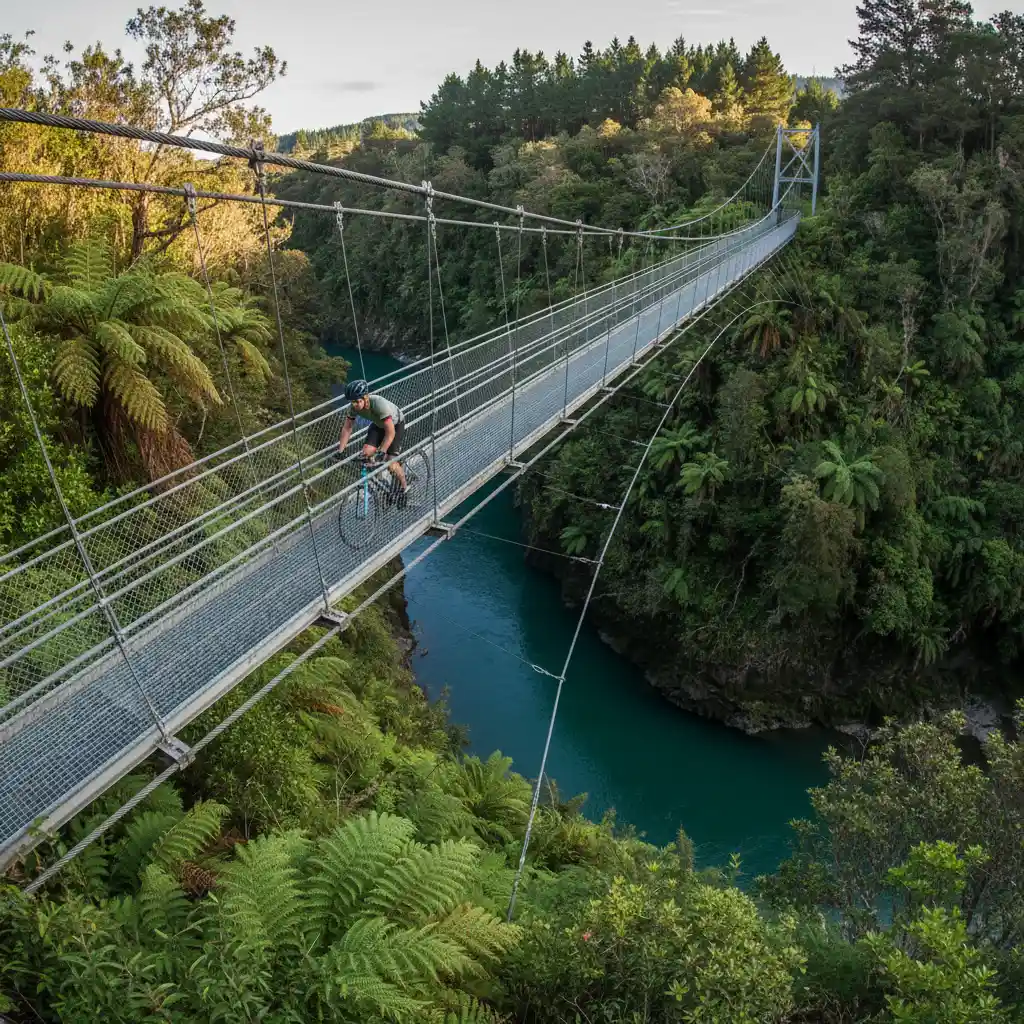
This is the technical heart of the trail. Leaving the historic Arapuni Village—famous for its hydroelectric dam and the iconic suspension bridge—the trail enters steeper terrain. Riders and hikers will navigate the slopes of Maungatautari (more on this sanctuary later). The path here can be narrow and includes switchbacks. It offers elevated views of the river that are inaccessible by road. The “Jim Barnett Reserve” is a key waypoint here, offering a glimpse into dense, preserved native forest.
3. Waipapa Section (Waipapa to Mangakino)
Distance: 19 km
Grade: Intermediate (Grade 3)
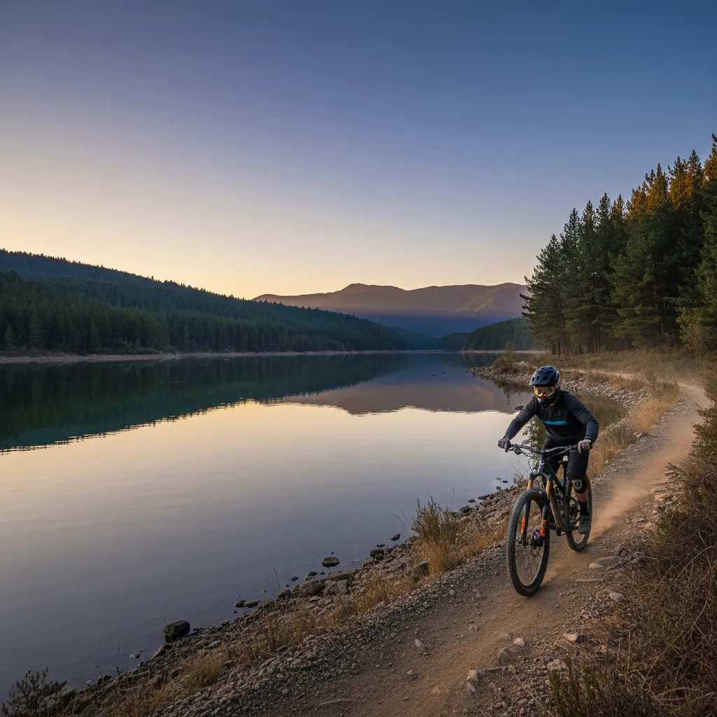
Connecting the Waipapa Dam to the town of Mangakino, this section combines gravel roads with single-track trails. It is a transition zone where the landscape shifts from dense bush to open lake views as you approach Lake Maraetai. Mangakino serves as a crucial hub for resupply and rest, situated perfectly for a mid-trip break. The terrain here is rolling but manageable for fit cyclists.
4. Maraetai Section (Mangakino to Whakamaru)
Distance: 12 km
Grade: Intermediate (Grade 3)
This is widely regarded as one of the most scenic sections. The trail hugs the edge of Lake Maraetai, providing constant water views. The typography is gentler here than the Arapuni section, making it a favorite for those who want scenery without the grueling climbs. You will cross the Mangakino Stream suspension bridge, a favorite spot for photographers.
5. Whakamaru Section (Whakamaru to Atiamuri)
Distance: 26 km
Grade: Intermediate (Grade 3)
The southernmost leg of the journey takes travelers to the majestic Whakamaru Dam. This section is characterized by pine forests and farmland, offering a different visual palette. The trail ends (or begins) at Atiamuri, dominated by the distinctive volcanic plug of Pohaturoa Rock, a significant site in Māori history.
Sanctuary Mountain Maungatautari: Visitor Guide
No eco-tourism itinerary in the Waikato is complete without a detour to Sanctuary Mountain Maungatautari. Located just west of the Arapuni section of the river trails, this is the largest ecological island on mainland New Zealand.
What makes Maungatautari unique?
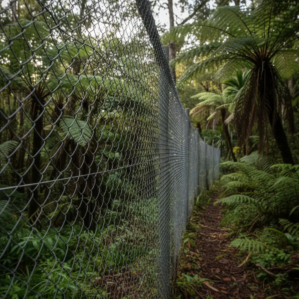
Maungatautari is an ancient volcanic cone surrounded by a 47-kilometer pest-proof fence. This fence is an engineering marvel designed to exclude all mammalian predators, including rats, stoats, possums, and feral cats. Inside this perimeter, the forest has been restored to a pre-human state of biodiversity. For travelers interested in regenerative tourism, visiting the sanctuary directly funds the maintenance of this fence and the protection of the species within.
Key Experiences at the Sanctuary
- The Southern Enclosure (Te Tūī a Tāne): This is the most accessible area for visitors. Well-maintained walking tracks take you deep into the tawa and podocarp forest. Here, you are almost guaranteed to see North Island Robins (Toutouwai) and Saddlebacks (Tīeke).
- Guided Night Tours: To truly appreciate the sanctuary, a night tour is essential. This is your best opportunity to spot the Western Brown Kiwi in its natural habitat and see the forest glow with bioluminescent fungi and glowworms.
- Tuatara Encounter: The sanctuary is home to a population of Tuatara, the “living dinosaur” endemic to New Zealand. Viewing these reptiles in a wild setting is a rare privilege.
Birdwatching Spots along the Waikato River
The Waikato River Trails act as a wildlife corridor, connecting various habitats. While Sanctuary Mountain is the crown jewel, the river corridor itself is teeming with birdlife, particularly in the wetland areas restored by local conservation groups.
Top Species to Spot
Kererū (New Zealand Wood Pigeon): You will hear the distinctive “whoosh” of their wings before you see them. These large, green-and-white birds are crucial for the forest as they are the only birds large enough to disperse the seeds of certain native trees like the Karaka and Tawa.
Tūī and Bellbird (Korimako): Listen for the complex songs of the Tūī and the bell-like chime of the Korimako. They are prolific nectar feeders and can often be found in flax bushes (Harakeke) along the riverbanks, particularly near the Karapiro and Arapuni sections.
New Zealand Grebe (Weweia): In the quieter bays of Lake Maraetai and Lake Whakamaru, look for the rare New Zealand Dabchick. These small diving birds are threatened, and the hydro-lakes of the Waikato have become a stronghold for their population.
Kārearea (New Zealand Falcon): In the pine forestry blocks near Atiamuri, keep an eye on the sky. The New Zealand Falcon is faster and more aggressive than the majestic Harrier Hawk and often hunts in open plantation forests.
Eco-Friendly Accommodation in Hamilton & Surrounds
To align your stay with the principles of regenerative travel, choose accommodation providers that prioritize sustainability. The Waikato region, specifically around Hamilton, Cambridge, and the trailheads, offers several options.
Choosing Sustainable Stays
When booking, look for “Qualmark Enviro-Gold” ratings. This accreditation ensures the business excels in energy efficiency, waste management, and community engagement. Staying in Cambridge is often strategic, as it serves as a central point between the trails and Hamilton city.
Types of Eco-Accommodation
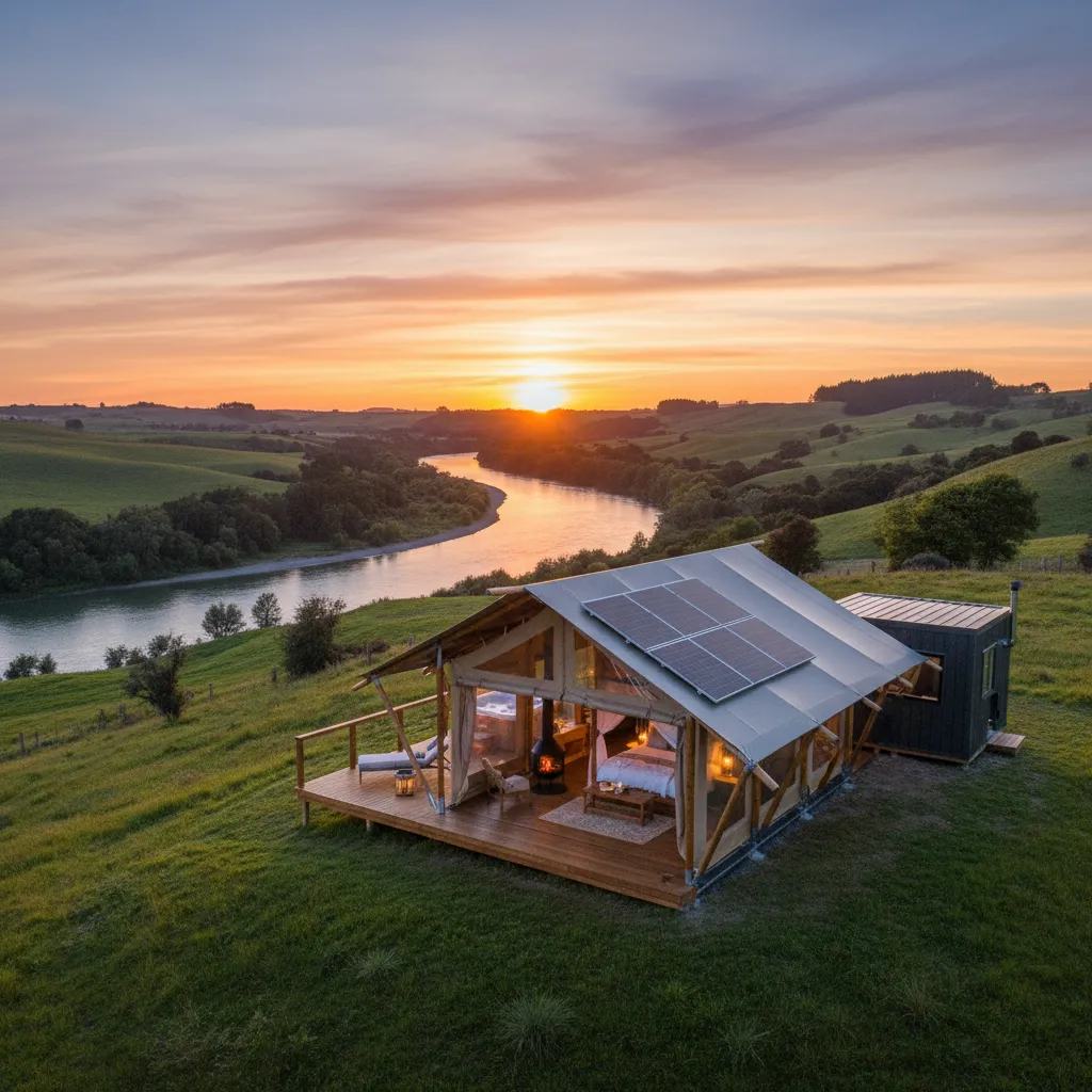
- Glamping & Off-Grid Cabins: Several providers near Lake Karapiro offer off-grid luxury tents. These usually utilize solar power, composting toilets, and rainwater harvesting, minimizing the carbon footprint of your stay while keeping you immersed in nature.
- Farmstays with Restoration Projects: Many local farms now offer accommodation where a portion of the profits goes toward riparian planting (planting natives along waterways to improve water quality). Staying here often allows guests to participate in tree planting, contributing directly to the regeneration of the Waikato catchment.
- Boutique Lodges: For higher-end travelers, lodges near Maungatautari often partner with the sanctuary, offering exclusive packages that include donations to conservation efforts.
Planning Your Trip: Logistics and Safety
Successfully navigating the Waikato River Trails requires more than just a map; it requires logistical foresight. The trails are linear, not circular, meaning you need to arrange transport.
Shuttles and Bike Hire
Because the trail is 103km one way, most visitors utilize shuttle services. Operators based in Putāruru, Tokoroa, and Cambridge can drop you at the southern end (Atiamuri) so you can ride north, or pick you up at specific section endpoints. If you are hiring a bike, consider an e-bike. The terrain, while not mountainous, is undulating, and an e-bike makes the Grade 3 climbs significantly more enjoyable, allowing you to focus on the scenery rather than fatigue.
Best Time to Visit
Shoulder Seasons (Spring and Autumn): November and March/April are ideal. The weather is stable, and the temperatures are cooler than the peak summer heat. Winter riding is possible but can be muddy in the forested sections. Summer brings high tourist numbers and heat, which can be taxing on the exposed sections near the dams.
Safety Considerations
Mobile phone coverage is spotty along the trails, particularly in the Arapuni and Waipapa sections. It is advisable to carry a Personal Locator Beacon (PLB) if traveling alone. Always carry plenty of water, as potable water sources are limited to the main villages (Arapuni, Mangakino, Whakamaru).
Regenerative Travel: The Tiaki Promise
New Zealand promotes the “Tiaki Promise”—a commitment to care for New Zealand, for now and for future generations. As a visitor to the Waikato River Trails, you act as a guardian (kaitiaki) of this land.
How to uphold the promise on the trails:
- Clean Gear: Before entering the trails or Sanctuary Mountain, scrub your boots and bike tires to prevent the spread of Kauri Dieback disease and invasive weeds.
- Pack In, Pack Out: There are very few rubbish bins on the trails. Carry all waste out with you.
- Respect Cultural Sites: The Waikato River is a tupuna (ancestor) to the local Māori iwi. Treat the water and the land with deep respect, avoiding prohibited areas and acknowledging the spiritual significance of the river.
People Also Ask
How long does it take to cycle the Waikato River Trails?
Most cyclists complete the full 103km trail in 2 to 3 days. This allows for a comfortable pace to enjoy the scenery and manage the intermediate terrain. Advanced riders can complete it in one long day, but this leaves little time for sightseeing.
Is the Waikato River Trail difficult?
The trail is graded mostly Grade 3 (Intermediate), with some Grade 4 sections. It requires a reasonable level of fitness and bike handling skills. It is not a flat rail trail; expect steep climbs, gravel surfaces, and some technical corners.
Are dogs allowed on the Waikato River Trails?
No, dogs are generally not allowed on the majority of the Waikato River Trails. The trail crosses private farmland and ecological reserves where dogs pose a risk to livestock and native wildlife.
Can I walk the Waikato River Trails instead of cycling?
Yes, the entire trail network is open to walkers and runners. Many hikers choose to tackle specific sections, such as the Arapuni to Waipapa leg, as day walks rather than walking the entire 103km length.
Where can I park for the Waikato River Trails?
There are designated parking areas at the main access points: Pokuru, Arapuni Village, Waipapa Dam, Mangakino Lakefront, Whakamaru Dam, and Atiamuri. It is safer to leave vehicles in populated areas like Arapuni or Mangakino rather than isolated roadside stops.
Is there a shuttle service for the trails?
Yes, several local operators provide shuttle services. They can transport you, your bike, and your luggage between trail sections or back to your vehicle. Booking in advance is highly recommended, especially during the summer season.