To find south using the Southern Cross, locate the constellation Crux and the two bright “Pointer” stars (Alpha and Beta Centauri). Imagine a straight line extending from the long axis of the cross. Next, draw an imaginary perpendicular bisector from the line connecting the two Pointers. The point where these two imaginary lines intersect marks the South Celestial Pole. Drop a vertical line from this intersection to the horizon to identify due south.
For outdoor enthusiasts exploring the rugged landscapes of New Zealand, from the Southern Alps to the dark skies of Stewart Island, mastering celestial navigation is more than a party trick—it is a vital survival skill. While modern GPS technology is reliable, batteries fail and electronics break. The stars, however, have guided travelers across the Pacific for millennia. Understanding how to interpret the southern night sky connects you to the ancient traditions of navigation and ensures you can always find your bearings in the wilderness.
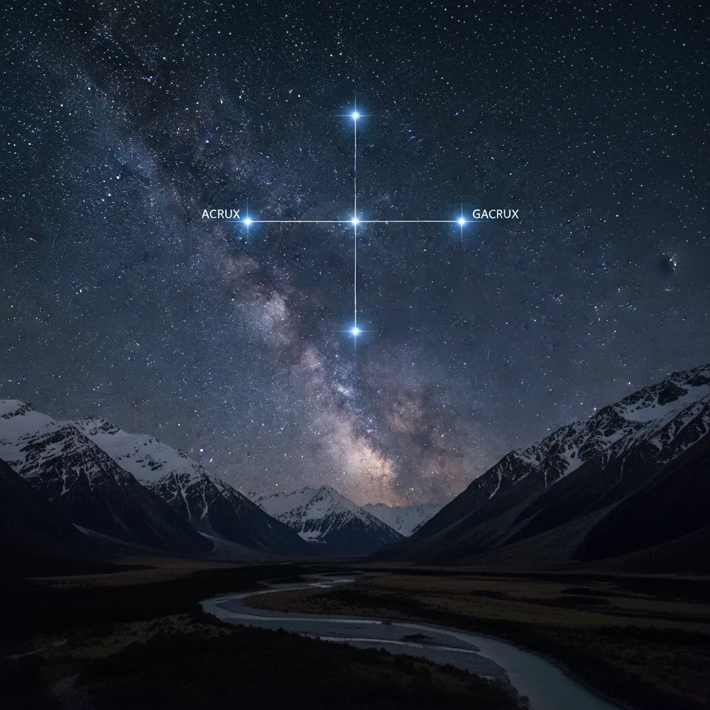
Identifying the Southern Cross (Crux)
The Southern Cross, astronomically known as Crux, is the smallest of the 88 modern constellations, yet it is arguably the most distinct feature of the southern hemisphere’s night sky. It is circumpolar in New Zealand, meaning it never sets below the horizon for most of the country, circling the South Celestial Pole throughout the night.
To successfully navigate, you must first be able to identify the specific stars that make up the constellation. The cross consists of four primary stars forming a kite-like asterism, with a faint fifth star often visible in dark sky locations like the Mackenzie Basin.
The Key Stars of Crux
- Acrux (Alpha Crucis): The brightest star in the constellation, located at the bottom of the cross (the foot). It is actually a multiple star system that appears as a single brilliant blue-white point of light.
- Mimosa (Beta Crucis): The second brightest, located at the left arm (eastern side) of the cross.
- Gacrux (Gamma Crucis): The red giant star at the top of the cross. Its reddish hue contrasts sharply with the other blue-white stars.
- Delta Crucis: The fainter star on the right arm (western side).
- Epsilon Crucis: The small, fifth star located between the bottom and right-hand stars, distinguishing the true Southern Cross from other cross-like patterns.
Distinguishing the True Cross from the False Cross
One of the most common mistakes made by novice navigators is confusing Crux with the “False Cross.” The False Cross is an asterism formed by stars in the constellations Vela and Carina. It is larger, dimmer, and lacks the fifth star (Epsilon Crucis). Furthermore, the False Cross does not have the two bright “Pointer” stars nearby.
Mistaking the False Cross for the Southern Cross can lead to significant navigation errors, potentially sending a hiker southwest instead of south. The most reliable way to confirm you are looking at the true Southern Cross is to look for the Pointers.
The Primary Method: Using the Pointers
The most accurate way to find the South Celestial Pole (SCP) involves using the “Pointers.” These are two very bright stars, Alpha Centauri and Beta Centauri, located to the left of the Southern Cross.
Understanding Alpha and Beta Centauri
Alpha Centauri (Rigil Kentaurus) is the third brightest star in the night sky and our closest stellar neighbor. Beta Centauri (Hadar) is slightly dimmer but still distinct. Together, they “point” towards the Southern Cross, helping you verify its identity.
Step-by-Step: The Intersection Method
This geometric method is the gold standard for finding south without a compass.
- Draw the Axis of the Cross: Imagine a straight line connecting the top star (Gacrux) and the bottom star (Acrux). Extend this line out into the dark patch of sky below the cross.
- Connect the Pointers: Draw an imaginary line connecting Alpha Centauri and Beta Centauri.
- Create a Perpendicular Bisector: From the center of the line connecting the Pointers, imagine a line shooting out at a 90-degree angle (perpendicular) toward the line coming from the Southern Cross.
- Find the Intersection: The point where the axis of the Southern Cross and the perpendicular bisector of the Pointers meet is the South Celestial Pole (SCP).
- Project to the Horizon: From that intersection point in the sky, drop a vertical line straight down to the horizon. That landmark on the horizon is due South.
This method compensates for the rotation of the earth. Regardless of the orientation of the Cross (whether it is upright, on its side, or upside down), this geometric relationship remains constant.

The Alternative Method: The 4.5 Times Rule
If the Pointers are obscured by clouds or terrain, or if you need a quicker, rougher estimation, you can use the axis method. While slightly less precise than the intersection method, it is generally sufficient for hiking orientation in open terrain like the Tongariro Crossing or the Kepler Track.
To use this method, take the distance between Gacrux (top star) and Acrux (bottom star). Imagine extending that distance 4.5 times downwards from the bottom star. The end of this imaginary line roughly marks the South Celestial Pole. From there, look straight down to the horizon to find south.
Note: This method is most effective when the Southern Cross is relatively high in the sky. When it is low to the horizon, atmospheric distortion and visual perspective can make judging “4.5 times” difficult.
Historical Māori Navigation (Tātai Arorangi)
Long before European explorers utilized sextants, Māori ancestors navigated the vast Pacific Ocean using a sophisticated understanding of the stars, ocean swells, and bird migration patterns. This knowledge system is known as Tātai Arorangi.
Te Punga (The Anchor)
In Māori astronomy, the Southern Cross is often referred to as Te Punga (The Anchor). In some iwi (tribal) traditions, it is seen as the anchor of the great waka (canoe) of Tama-rereti (represented by the tail of the Scorpius constellation). The Pointers are sometimes viewed as the rope of the anchor.
When the anchor (Southern Cross) is high in the sky, it signifies that the waka is anchored safely. As the earth rotates and the cross appears to set, the anchor is being lifted. For early Polynesian navigators, these stars were not just static points but dynamic tools used to maintain a course across thousands of kilometers of open ocean to reach Aotearoa.
Mahutonga
Another common name for the Southern Cross in Māori culture is Mahutonga. The ability to read Mahutonga and other celestial bodies was essential for survival, determining seasons for planting (connected to the rising of Matariki), and navigating terrestrial routes across the dense New Zealand bush.

Conservation and New Zealand’s Dark Skies
New Zealand is uniquely positioned as a world leader in dark sky conservation. The ability to see the Southern Cross clearly is dependent on low light pollution, a resource that is rapidly disappearing globally. New Zealand hosts several Dark Sky Sanctuaries and Reserves, including the Aoraki Mackenzie International Dark Sky Reserve, Great Barrier Island (Aotea), and Stewart Island (Rakiura).
Why Dark Skies Matter for Eco-Tourism
For the eco-tourist, these reserves offer a glimpse into the past—a view of the sky identical to what Māori navigators saw 800 years ago. Preserving these skies is critical not just for tourism, but for the biodiversity of New Zealand. Many native species, including nocturnal birds like the Kiwi and various insects, rely on natural light cycles for breeding and feeding.
When practicing celestial navigation, you are participating in a form of heritage conservation. You are utilizing the natural environment without altering it. Hikers are encouraged to use red-light torches to preserve night vision and minimize light pollution while observing these celestial markers.
Navigating New Zealand’s Wilderness
While finding south using the Southern Cross is a fundamental skill, applying it in the New Zealand context requires awareness of the terrain. The “True South” indicated by stars differs from “Magnetic South” shown on a compass. In New Zealand, the magnetic declination is roughly 20 to 25 degrees east. However, the stars always point to True South.
If you are lost in the bush:
- Find a clearing with a view of the southern sky.
- Use the intersection method to identify a landmark on the horizon (a peak, a saddle, or a distinct tree).
- Orient your map using this True South landmark.
- Plan your route towards safety, keeping in mind that the stars will rotate around the pole as the night progresses, but the South Celestial Pole itself remains fixed.

Mastering the Southern Cross is a rite of passage for any Kiwi outdoors person. It connects the modern adventurer with the ancient wayfinders, grounding us in our location on the planet and offering a reliable guide home when technology fails.
What if the Southern Cross is upside down?
The method still works. The Southern Cross rotates around the South Celestial Pole like the hand of a clock. Whether it is upright, sideways, or upside down, the line extending from its vertical axis always points toward the pole. You simply extend the line from the “top” star (which is now at the bottom) through the “bottom” star (now at the top) towards the pole.
Can I use the Southern Cross to find South in the Northern Hemisphere?
Generally, no. The Southern Cross is not visible from most of the Northern Hemisphere (above 25 degrees North latitude). In the Northern Hemisphere, navigators use Polaris (the North Star) to find North. However, near the equator, it may be possible to see the Southern Cross low on the horizon depending on the time of year.
Why is there a ‘False Cross’?
The ‘False Cross’ is a coincidence of perspective. It is an asterism formed by stars in the Vela and Carina constellations that visually resembles Crux. It is often mistaken for the real cross because it is slightly larger and often oriented similarly, but it lacks the fifth star and the bright Pointers.
What are the Pointers in the Southern Cross?
The Pointers are Alpha Centauri and Beta Centauri. They are two of the brightest stars in the southern sky and are located “to the left” of the Cross (clockwise). They are called Pointers because a line drawn connecting them points toward the Southern Cross, helping to distinguish it from the False Cross.
Does the Southern Cross move during the night?
Yes. Like all stars, the Southern Cross appears to move due to the Earth’s rotation. It circles clockwise around the South Celestial Pole. In New Zealand, it is circumpolar, meaning it is visible all night and never sets below the horizon, though its orientation changes (it ‘tumbles’) throughout the night.
How accurate is finding south with the Southern Cross?
If performed correctly using the intersection method with the Pointers, it is accurate to within a few degrees of True South. The ‘4.5 times’ method is an approximation and can be off by 5-10 degrees depending on estimation errors, but is usually sufficient for general hiking orientation.